It’s time to know which path to take—literally. Due to the Philippines’ geographical location, the country is prone to tropical cyclones that typically bring heavy rains and flooding across large areas. The first half of 2024 introduced us to record-breaking heat indexes, but the second half is expected to bring several typhoons and heavy rainfall lasting until November.
Metro Manila, as the country’s political, economic, and educational center and the most densely populated region with 16 highly urbanized cities, has several identified flood-prone areas.
Therefore, if you’re planning to travel around Metro Manila during the rainy season, here’s a list of areas you might want to avoid during your daily commutes.
Flood-Prone Areas in Metro Manila That You Should Avoid During Rain
Manila and Quezon City are two of the most flood-prone areas in Metro Manila. As much as possible, it is safer to avoid the following locations in these cities during heavy downpours due to the heightened risk of flooding, which may result in heavy traffic, stranded vehicles, and other safety and health hazards:
Manila:
- Blumentritt
- Maria Clara St. to Calamba St.
- Dimasalang Ave.
- Makiling St. to Retiro St./Maceda St.
- Maceda St.
- PIY Margal St. to Makiling St.
- PIY Margal St.
- Maceda St. to Blumentritt St.
- Dapitan St.
- Cristobal St. to Maceda St.
- Laong Laan St.
- Andalucia St. to A.H. Lacson St.
- Andalucia St.
- Dapitan St. to Maria Clara St. (North Bound)
- Remigio St. to Malabon St. (South Bound)
- Dapitan St.
- A.H. Lacson St. to Andalucia St.
- España Blvd.
- Antipolo St. to Blumentritt
- Rizal Ave.
- C.M. Recto Ave. to Doroteo Jose St.
- C.M. Recto Ave.
- Rizal Ave. to Evangelista St.
- Legarda St.
- Corner Gastambide St.
- Quezon Blvd.
- foot of Quezon Bridge (North Bound)
- Ramon Magsaysay Blvd.
- D. Ampil St. to Ramon Magsaysay Bridge
- V. Mapa St.
- Guadal Canal St. to Old Sta. Mesa St.
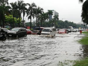
Photo courtesy: Philippine News Agency
Quezon City:
District I
- EDSA (Northbound)
- Near Balintawak Depot
- North Avenue Cor. EDSA
- C-3 (Sgt. Rivera) Cor. A. Boniacio Ave.
- Araneta Ave.
- Talayan Creek
- Ma. Clara St. to Del Monte Ave.
District II
- Quirino Highway
- Baesa Road-Mendez Creek
- Tandang Sora Ave.
- Venus St.-Doña Soltera St.
- Commonwealth Avenue Cor. Tandang Sora Ave.
- Commonwealth Avenue Cor. Feria Road
- Commonwealth Avenue Cor. Bitoon Circle
- Commonwealth Avenue Cor. Winston St.
District III
- P. Tuazon St. Corner 18th Avenue / 20th Avenue
- EDSA– Aurora Blvd.
- Aurora Blvd., Corner Harvard St.
- Katipunan Avenue Fronting Ateneo De Manila
District IV
- Anonas Corner V. Luna St.
- Elliptical Road Fronting Quezon City Hall / DAR
- Mother Ignacia Near ABS-CBN, Near Timog Avenue
- Timog Avenue Corner Scout Tobias
- E. Rodriguez Sr. Blvd., Fronting De Los Santos Hospital
- Araneta Avenue Near E. Rodriguez Sr. Blvd./Fronting La Funenaria Paz
- Quezon Avenue Corner Biak Na Bato / Victory St.
- Kamuning Road Near Corner 11th Jamboree/Metrobank
- T. Morato Cor. Sct. Lozano
The MMDA identified the City of Manila as having the highest number of flood-prone streets among the 16 highly urbanized cities in the National Capital Region (NCR).
Subsequently, MMDA also tagged Quezon City as having the second-highest number of flood-prone areas, followed by Makati City and Pasay.
In addition to Quezon City and Manila, there are other areas in Metro Manila that are highly susceptible to flooding. The majority of these areas have a high risk of flooding due to intense rainfall with more than 50 mm per hour. Below is a list of 10 of these flood-prone places.
1. Pasig City
- Rosario-Cainta Road
- Corner Tramo fronting Shell
- Imelda Ave.
- Fronting Pasig Green Park
- V.V. Soliven
- CVS Home Fronting Shell
- Amang Rodriguez Ave.
- Corner Marcos Highway (ligaya)
- South Supermarket
- C-5 E. Rodriguez Jr. Ave.
- Corner Eagle Street
- Ortigas Ave., Fronting De Castro Subd.
- Fronting Green Meadows
2. Marikina City
- Barangka Drive
3. Malabon City
- Gov. Pascual Ave.
- LTO
- Catmon
- Maria Clara
- Sanciangco St.
- M.H. Del Pilar
- Maysilo corner Yanga Bridge
- Yanga St.
- Letre/P. Aquino Rd.
- Dagat-Dagatan Ave. Ext.
- C-4 Citi Square
- General Luna
- Women’s Club
- J. P. Rizal Ave.
- Adante
- Letre
4. Navotas
- North Bay Blvd. (Agora)
5. Caloocan City
District 1
- Gen. Luis St. Cor. ITC Compound, Bagbaguin
- Gen. Luis St. Cor. Silver Road, Kaybiga
District 2
- Samson Road from Gen. Pio Villanueva St. to Lapu-lapu St., Sangandaan
- 10th Ave. from Roxas St. to Baltazar St., West Gracepark
- Tulingan St. from Sabalo St. to Libis Talisay, Dagat-Dagatan
- Dagat-Dagatan Av. from Tanigue St. to Tulingan St., Dagat-Dagatan
- 8th Ave. from 4th St. to 7th St., East Grace Park
- 9th Ave. from 4th St. to 7th St., East Grace Park
- 10th Ave. from 4th St. to 7th St., East Grace Park
- 11th Ave. Ave. from 4th St. to 7th St., Grace Park
- 4th St. from 8th Ave. to 11th Ave., East Grace Park
- Boni Serrano Ave. from 8th Ave. to 11th Ave., East Grace Park
- 6th St. from 8th Ave. to 11th Ave., East Grace Park
- 7th St. from 8th Ave. to 11th Ave., East Grace Park
- J.P. Rizal from J.P. Rizal Ext. to San Miguel St., Maypajo
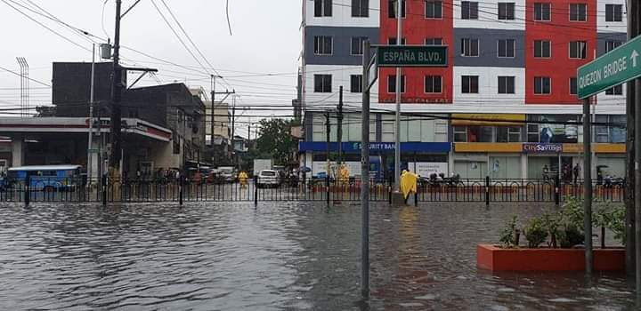
ESPAÑA Boulevard in Manila. Photo by Twitter user @PieIncha
6. Makati City
- Buendia Ave.
- Bautista-Washington
- EDSA-Pasong Tamo Tunnel
- EDSA-Ayala Tunnel
- Pasong Tamo
- Yague-J. P. Rizal
- Magallanes Interchange
- C5-Kalayaan
- Pasong Tamo
- Arnaiz-Don Bosco
- SLEX under Sales Bridge
7. Pasay City
- EDSA-Taft
- Taft-Protacio
- Domestic Road Corner MIA Road
- Roxas Blvd.
- San Juan-Sta. Monica
- Aurora Ave. – Corner Andrews
- F. B. Harrison – EDSA
- B. Harrison – Balagtas
- Taft Avenue Extension Baclaran
- Roxas Blvd. fronting Madrigal
- Andrews Avenue (Oval)
8. Valenzuela City
District 1
- Fermin Alcanar St. from Alcanar St. to Mansanas St., Wawang Polo
- Bilog Road from Mansanas St. to Anonas St., Wawang Polo
- Tagalag Road from Waling-Waling St. to Adelfa St., Tagalag
- Coloong I from Geronimo St. to Dela Castillo St., Coloong
- Coloong II from Marcos St., to San Diego St., Coloong
- Juan Santiago St. from M.H. Del Pilar St. to end road, Malanday
- T. Santiago St. Bet. Veinte Reales Creek to Caltex Gas Station, Linguan
District 2:
- MacArthur Highway from San Guillermo St. to Karuhatan Road, Karuhatan
- Karuhatan Road from MacArthur Highway to Ilang-Ilang St., Karuhatan
- MacArthur Highway from Marulas Creek to Tamaraw Hills St., Marulas
- Gen. T. De Leon St., Bet. Angeles St. to De Guia St., Gen. T. De Leon
9. Parañaque City
- Baclaran Vicinity
- Junction of Redemptorist
- Quirino Ave. & F.B. Harrison
- Roxas Blvd.
- Service Road in front of Chowking
- Quirino Avenue, Cor. Kabihasnan
- Quirino Avenue, Tambo
- Sucat Road From Olivarez To SM
- Sucat Interchange Fronting Jollibee
- East Service Rd. Cor. Bagong Tanyag
- East Service Rd. in front of Daughters of Charity Provincial House
10. Mandaluyong City
- EDSA Cor. Connecticut
- Ortigas Ave. Fronting De La Salle
- EDSA-Shaw Blvd. Underpass
- Shaw Blvd. Cor. Acacia Lane
- Shaw Blvd. – J. Luna To JRU
- Gen Kalentong
-
- Shaw Blvd. To Maytunas Creek
- Boni Avenue, Cor. F. Ortigas St.
- Boni Avenue-Sto. Rosario To San Joaquin
In addition to this, a recent study by the Metropolitan Manila Development Authority (MMDA) reveals that Metro Manila is prone to floods, not just because of the rising seas, but also if dumped with an hour of continuous rain.
Furthermore, Marikina City, where one of the largest MMDA pumping stations is located, is a catch basin of water coming from Quezon City and the province of Rizal, making it a flood-prone area.
You can check out the full list of Metro Manila flood-prone areas released by MMDA through this link.
How’s the flood situation in your area?
CITATIONS
-
Laurel, D. (2019, July 5). The 10 most flood-prone cities in Metro Manila according to Waze. Top Gear Philippines. https://www.topgear.com.ph/news/motoring-news/10-most-flood-prone-cities-waze-a962-20190705
-
Cayabyab, M. J. (2019, November 13). Manila has NCR’s most flood-prone streets – MMDA. PhilStar. https://www.philstar.com/nation/2019/11/13/1968245/manila-has-ncrs-most-flood-prone-streets-mmda
-
MMDA Gears Up for Rainy Season; Ensures Fully Operational Pumping Stations. (2021, June 2). MMDA. https://mmda.gov.ph/77-news/news-2021/4670-june-2-2021-mmda-gears-up-for-rainy-season-ensures-fully-operational-pumping-stations.html
-
MMDA Chair Abalos: Pumping Stations Must Be Ready Before Rainy Season. (2021, January 15). MMDA. https://mmda.gov.ph/77-news/news-2021/4450-january-15-2021-mmda-chair-abalos-pumping-stations-must-be-ready-before-rainy-season.html